Author:
Mark Wilkerson, Product Manager at Point One Navigation
Date
05/20/2024
 PDF
PDF

Click image to enlarge
Figure 1: Faction Delivery Vehicles rely on Point One Navigation’s RTK Correction services to know where they are and where they are going
In today’s engineering tasks, location precision is more critical than ever — particularly when it comes to accurately measuring geospatial positioning. From construction and farming to building and operating autonomous vehicles, pinpoint accuracy is critical for safety and efficiency. Whether using drones to map survey sites for building solar farms and urban centers, planning for more efficient resource allocation in agriculture, or ensuring self-driving vehicles navigate their routes safely, engineers must be confident in the positioning measurements that guide these tasks.
As has been the case for decades, they’ll continue to rely on Global Navigation Satellite Systems (GNSS) to provide these measurements. But, as many engineers know, GNSS have always required corrections to improve their accuracy, especially for precision applications in engineering.
Real-time kinematic (RTK) corrections have long been one of the best methods for ensuring GNSS precision. Yet, many engineers are still unfamiliar with this technology, or they’ve avoided it due to its potential to drain time and resources. However, RTK corrections — with the proper setup and infrastructure — are essential for achieving the precision required by today’s most challenging engineering tasks.
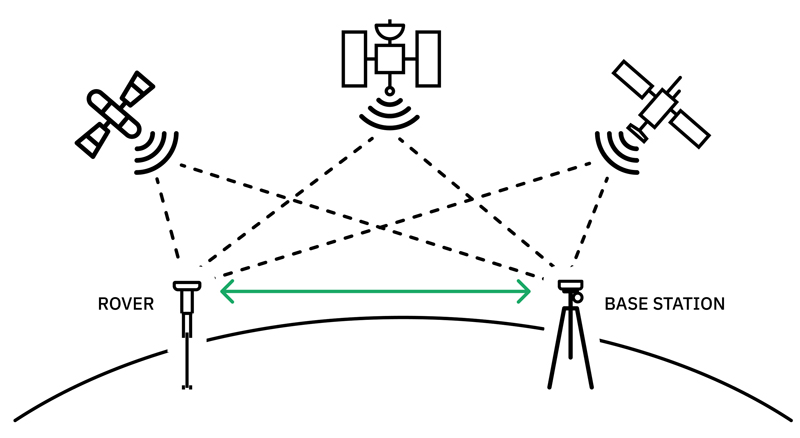
Click image to enlarge
Figure 2: Relying on a network of ground based base stations, RTK positioning technology communicates with satellites and rovers to achieve centimeter-level positioning
How GNSS Falls Short of Precise Positioning
Are GNSS corrections really necessary for engineers? After all, drivers rely on GNSS like the Global Positioning System (GPS) in the U.S. every day to accurately navigate the roads, and that gets the job done — do engineers require something more precise than that?
In short, yes, they do. GNSS measurements are not even close to what engineers need. On their own, GNSS measurements can be off by a few meters or more. When you’re dealing with major construction projects, survey mapping, or autonomous delivery vehicles, that’s simply unacceptable.
These errors are unavoidable because they’re inherent to how GNSS systems work. Typical error sources include ephemeris inaccuracies, satellite clock discrepancies, ionospheric disturbances, tropospheric conditions, and biases among various satellite systems. Let’s explore how each of these can impact accuracy.
Ephemeris are data sets that provide information about the location of celestial bodies in space at regular intervals. Satellites use ephemeris to transmit information about their location and velocity to GNSS receivers on Earth.
Even though this data is transmitted frequently, receivers may not always have the most up-to-date data. This can lead to miscalculations of the satellite’s location — and, as a result, the receiver’s position.
Without precise knowledge of the satellite’s position or accurate location information, the signals cannot align correctly. This compromises the accuracy of the position and signal transmission/reception time, throwing off measurements, by a meter or more.
To obtain distance measurements between receiver and satellite, receivers rely on satellites’ built-in atomic clocks. These clocks are highly accurate but not entirely error free. Satellites travel at roughly 7,000 miles per hour, and this can introduce slight differences (microseconds) between time measurements on the ground vs. space. Random errors can also throw off satellite clocks, and ground control stations only make corrections every few hours.
These clock discrepancies may be minor, but even slight variances can lead to substantial positioning errors. When the receiver’s perception of the time of signal transmission is off, it can easily offset positioning accuracy by a few meters.
The outer layer of the Earth’s atmosphere, known as the ionosphere, is loaded with electrons, and this creates a charged electrical environment that can distort radio signals and affect the speed of light. Ionospheric activity can also fluctuate in conjunction with changes in solar radiation, leading to unpredictable delays or distortions in GNSS signals.
These delays throw off readings on the ground — enough so that measurements are unreliable for a wide variety of applications.
The troposphere is the inner layer of the atmosphere, closest to the ground and responsible for weather phenomena. Changes in temperature, humidity, and atmospheric pressure can all affect GNSS signals and throw off measurements.
Tropospheric conditions don’t throw off GNSS measurements as much as other forms of interference, but errors are still significant enough to cause problems in engineering project execution. These conditions are also highly localized, requiring correction from a relatively close distance.
There are numerous GNSS around the world — from GPS to GLONASS to BeiDou — and each is run by a different country. Different time references and frequencies for each system lead to what are known as code biases, or discrepancies among the signals coming from each satellite constellation. These, too, can affect the accuracy of GNSS measurements.
RTK for GNSS: The Basics
RTK systems rely on a few different components to provide corrections for these errors in GNSS signals.
First and foremost are the RTK base stations, which provide a fixed point of reference to which to compare GNSS measurements. Because base stations are stationary on the ground, they know their exact location and can use that when communicating with RTK receivers, a second component in the system which applies this correction data to the measurements received from the GNSS. The closer these receivers are to the base station, the more accurate corrections will be.
In more advanced, precise applications, RTK providers deploy large networks of base stations and corrections devices. This creates a larger area of interconnected devices, allowing for a far more scalable corrections solution. These devices generate what’s called RTCM (Radio Technical Commission for Maritime Services) correction data, a standardized data format that can then be transmitted to the RTK receivers to provide precise location corrections.
The Mechanics of Achieving RTK Corrections
With these three basic components, RTK corrections offer a straightforward, reliable method for dealing with GNSS positioning errors. However, legacy methods for attaining RTK corrections were not always sufficient or practical.
Historically, firms in need of precise measurements have had two options:
● Building their own reference stations: Smaller operations like a localized drone mapping service can set up a personal GNSS reference station. Unfortunately, this is an expensive, time-consuming process that requires serious technical expertise.
● Connecting to public stations: Some organizations offer RTCM data through public stations. These public networks are free, but coverage can be limited, and up-time is not guaranteed. Network outages can cause costly delays that far outweigh the savings of using a free network. In other cases, such as in construction damage prevention, a network outage may lead to serious risk to underground utility lines.
A far better — and widely available — option nowadays is to connect to a dedicated RTK network like Point One Polaris. This provides wide-area coverage with continuous, guaranteed RTCM data for real-time corrections while avoiding the hassle and expense of setting up your own network. A dedicated network is especially beneficial for companies that require reliable, accurate corrections across a wide area.
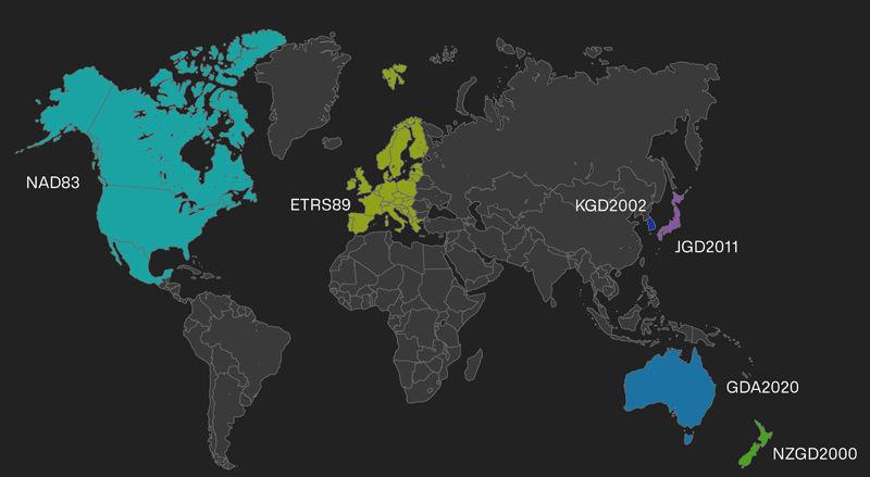
Click image to enlarge
Figure 3: Currently available through North America, Western Europe, South Korea, Japan, Australia and New Zealand, the Polaris RTK coverage map is consistently growing
Relying on a dedicated RTK network does far more than save money and guarantee reliable corrections — it brings a host of benefits for a wide range of applications that rely on precise positioning.
An extensive network of base stations and corrections devices accelerates signal convergence time, allowing engineers to capture measurements in real time. This correction speed can be over 200 times faster than public networks or a non-RTK service like precise point positioning.
Consider the difference this speed makes in, for instance, creating reliable self-driving race cars that require near-immediate, accurate positioning measurements. For autonomous cars to solidify their future on the track, they’ll need RTK precision that can safely guide them. Tests of such applications are already happening, with autonomous race cars reaching speeds of 180 miles per hour at the Indy Autonomous Challenge earlier this year.
As noted, a larger network means a broader coverage area. In the U.S., where moving across state borders could mean stopping work to set up a new internet connection and port, having an expansive network is essential.
A company like Civ Robotics saves countless hours and dollars by relying on the Polaris RTK Corrections Network. With projects that often extend across state lines, Civ Robotics must frequently move Rovers and reconnect to the network in a new state. Instead of setting up a new connection, the company can sync with Polaris and get right back up and running.
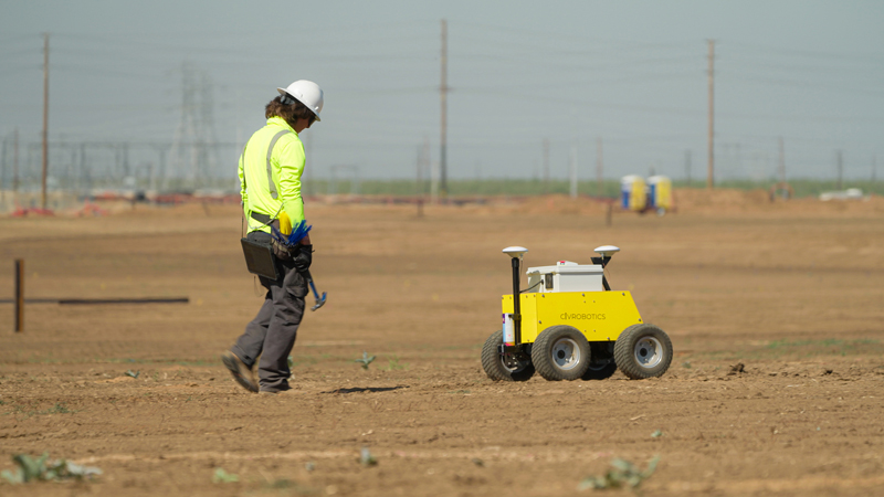
Click image to enlarge
Figure 4: Civ Robotics rovers can easily connect to the Polaris RTK network in any state to achieve reliable real-time corrections
A larger RTK corrections network also means more accurate measurements. With more corrections devices available, it’s easier to ensure receivers are near a base station. This results in data that’s accurate to within less than a centimeter in many cases.
Whether you’re planning a site excavation and need to avoid underground utility lines or you’re deploying self-driving delivery vehicles, that level of precision is invaluable. Faction, another Point One customer, uses Polaris to ensure its delivery cars place each package exactly where it belongs.
RTK networks like Point On Polaris are designed for ultimate ease of integration with an accessible application programming interface (API). This allows for quick and seamless integration of RTK and GPS data into various software applications. With an accessible API, on-site managers can sidestep the complexity of REST APIs, avoid the hassle of learning multiple endpoints and data models, and skip the mess of setting up infrastructure for intermediate data stores and applications.
A network like Polaris also provides construction surveyors with built-in local datum capabilities, removing any need for an additional layer of data conversion to ensure accurate ground-level measurements. This takes the ease and affordability of RTK to an entirely new level for many engineering and construction projects.
Ease of Provisioning
With a simple API and a straightforward user interface, RTK networks like Point One make it easy to provision new GNSS devices on the field at a moment’s notice. There’s usually no complicated configuration required, and no need for technical knowledge. Engineers can easily scale their projects with a robust RTK corrections network.
RTK Corrections Provide True Precision for Engineers
Precision is a non-negotiable in the work of engineering. From deploying drones for survey work to relying on autonomous delivery vehicles, there has never been more demand for reliable, accurate measurements to ensure safe and efficient project execution. GNSS measurements are an essential tool, but they don’t provide accurate enough data on their own.
In most cases, RTK corrections are the most effective, affordable way to pull off the necessary level of precision for GNSS corrections in high-precision engineering tasks. Third-party RTK networks, in particular, allow engineers to ensure real-time accuracy without all the headaches that have often accompanied GNSS corrections.


